
Contents
- Tughlaqabad at a Glance
- Background: Where Tughlaqabad Fits in the “Cities of Delhi”
- Why Ghiyasuddin Tughlaq Built a New City
- The political moment
- The frontier and the Mongols
- The story of the Khalji joke
- What the chronicles say
- Why this site?
- How Tughlaqabad Was Built
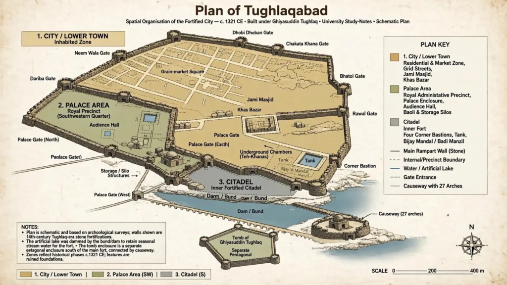
- Layout: A City, a Palace Area and a Citadel
- 1. The city (lower town)
- 2. The palace area
- 3. The citadel
- Defensive design in plain terms
- The Lake, the Dam and Water Supply
- Ghiyasuddin’s Tomb and the Pentagonal Enclosure
- Adilabad: Who Built It?
- Legends: Nizamuddin Auliya and the “Curse”
- The Death of Ghiyasuddin (1325): Accident or Conspiracy?
- Why Was Tughlaqabad Abandoned? A Debate, Not a Single Cause
- What older student notes claimed, and what the evidence supports
- Comparison: Tughlaqabad and Other Sultanate Capitals
- Tughlaqabad in the Historians’ Debate
- Tughlaqabad Today
- How to Write a Tughlaqabad Answer (Exam Plan)
- Quick Revision: Timeline
- Key Terms for Revision
- Conclusion
- Continue Reading
- University of Delhi Previous Year Questions (PYQs)
- Frequently Asked Questions (FAQs)
Tughlaqabad is the fortified city that Ghiyasuddin Tughlaq (r. 1320–1325), the founder of the Tughlaq dynasty, began building in 1321 on a rocky ridge in what is now South Delhi, beside the Mehrauli–Badarpur Road. It had everything a Sultanate capital needed: a walled city, a palace area, a heavily defended citadel, grain silos, step-wells and a man-made lake. Yet it was occupied for only a short time. According to the survey-based account on Sahapedia, the fort was occupied before it was fully built and was vacated after 1327 or 1329, and in any case by 1334.
That short life is exactly why DU teaches it. These notes cover Unit 2 of GE-1, Delhi Through the Ages (“From Settlements to Cityscape – Understanding the 10th and 14th Century Cities of Delhi”). The University of Delhi syllabus says this unit looks at why the Sultanate capitals shifted and how the character of the city changed, and that students undertake case studies of any two cities from a list that includes Tughlaqabad. So the examiner is not only asking what Tughlaqabad was. The real question is why a city this ambitious was left behind, and how historians argue about it.
Spelling note: The DU syllabus spells the name Tughulqabad. You will also see Tughluqabad and Tughlakabad in books and question papers. All four spellings mean the same city.
Tughlaqabad at a Glance
| Point | What the sources say |
|---|---|
| Founder | Ghiyasuddin Tughlaq (earlier Ghazi Malik), first Sultan of the Tughlaq dynasty, r. 1320–1325 |
| Construction | Began in earnest after the 1321 monsoon (Sahapedia). Fort occupiable by about 1323–24. Other accounts give slightly different dates (see the construction section) |
| Location | South Delhi, on the Mehrauli–Badarpur Road |
| Architect | Ahmad bin Ayaz, according to a summary of Shokoohy and Shokoohy’s research by historian S. A. N. Rezavi. Sahapedia’s overview does not name him |
| Size | About 6 km perimeter enclosing roughly 130 hectares, of which the city proper is about 100 hectares (Sahapedia). Wikipedia, citing a government publication, gives 6.4 km |
| Walls | Usually 10–15 m high, rising to about 30 m at the highest points; thickness up to about 10 m (Rezavi, summarising Shokoohy) |
| Material | Local sandstone and quartzite rubble bonded with lime mortar, faced with dressed quartzite (Sahapedia). Many websites say “granite”; the survey description is more precise |
| Three parts | The city, the palace area, the citadel |
| Water system | A dam (bund) across a seasonal stream created a lake on the southern side; step-wells, tanks and sluices |
| Linked structures | Ghiyasuddin’s tomb in a separate pentagonal enclosure connected by a causeway; the fort of Adilabad |
| End of use | Vacated after 1327 or 1329, and definitely by 1334 (Sahapedia) |
Background: Where Tughlaqabad Fits in the “Cities of Delhi”
Delhi is often called a city of many cities. Sultanate rulers repeatedly built new walled settlements instead of living in the old one. For this unit, keep the sequence clear:
| Settlement | Associated with | Where to read more |
|---|---|---|
| Lal Kot / Qila Rai Pithora | Tomar and Chauhan period, before the Sultanate | Lal Kot notes |
| Dihli-i Kuhna (“old Delhi”, the first Sultanate capital) | Early Sultans, centred on the Qutb area | Delhi-i Kuhna’s Masjid-i Jami |
| Siri | Alauddin Khalji, c. 1303 | Siri case study |
| Tughlaqabad | Ghiyasuddin Tughlaq, from 1321 | This article |
| Jahanpanah | Muhammad bin Tughlaq, late 1320s (dates vary by source) | Covered below in the comparison |
| Firuzabad | Firuz Shah Tughlaq, c. 1354 | Firuzabad case study |
Is Tughlaqabad the third or the fourth city? Books differ because they count differently. Wikipedia and several exam-prep sites call it the third city, counting Lal Kot (Qila Rai Pithora) first and Siri second. Rezavi’s blog calls it “conventionally” the fourth city, but its own numbered list places it third. Dihli-i Kuhna, Indraprastha and Purana Qila are sometimes added or skipped depending on the author. In an answer, write “third (or fourth, depending on how the earlier settlements are counted)” and move on. Examiners reward the argument, not the number.
Why Ghiyasuddin Tughlaq Built a New City
The political moment
The Khalji dynasty collapsed in 1320 after a coup by Khusrau Khan. Ghazi Malik, a senior commander, defeated him, and he took the title Ghiyasuddin Tughlaq in September 1320 (date from Wikipedia). His own background is debated. The sources differ on his ancestry, and Amir Khusrau’s Tughlaq Nama itself presents him as a man of modest beginnings. Do not describe him in your answer as a “slave of the Khiljis,” a phrase that circulates in student notes without support. What the sources do agree on is that he rose through military service.
The frontier and the Mongols
Before becoming Sultan, Tughlaq was charged with defending the Sultanate’s boundary at Multan–Dipalpur against Mongol raiders (Sahapedia). The threat came from the north-west, not from the south. That matters because older notes on this page claimed the Aravalli hills gave “a natural barrier against invasions from the south.” The better-supported point is different: the ridge and the lake together made the site hard to attack from the south and north. The fort was designed by someone who had spent years thinking about Mongol attacks, and Wikipedia also says he envisioned it as an impregnable fortress against Mongol marauders.
The story of the Khalji joke
A popular tradition says Ghiyasuddin advised the Khalji Sultan Mubarak to build a fortified city on this spot. Mubarak declined, jokingly telling him to build it himself once he became Sultan. Sahapedia reports this as “a saying,” and Wikipedia repeats it. Treat it as a tradition: it shows that the site was linked in memory with Ghiyasuddin’s frontier career, but it is not hard evidence.
What the chronicles say
Rezavi’s summary reports two points from the sources. Ziauddin Barani says construction started soon after Ghiyasuddin’s accession. Ibn Battuta says the site was already on Ghiyasuddin’s mind when he served as a minister under Mubarak Shah. The two statements are compatible with the tradition above and with a plan made well before 1320.
Why this site?
Sahapedia’s survey explains the terrain. The fort stands on a local high ground that slopes gently from west to east. A small stream, possibly not flowing all year, ran past its south side, and low hills lay a short distance further south. This made it possible to build a dam from the high ground to the hills and turn the stream into a lake, even if it shrank to a marsh in summer. The lake was a defensive obstacle on the south. It was also, as Rezavi notes, a water source for the town and for irrigating nearby fields.
Key Takeaways: Founding
- Ghiyasuddin built Tughlaqabad from 1321, after defeating Khusrau Khan and taking the throne in 1320.
- The motive was military: his earlier career was spent guarding the Multan–Dipalpur frontier against the Mongols.
- The site combined a rocky ridge with an engineered lake, so water and defence were planned together.
How Tughlaqabad Was Built
The details below come from two sources that do not agree on every point, so note which you are following.
- Early works. Narayan (Sahapedia) suggests Ghiyasuddin may first have built a smaller fortification, today called Nai ka Kot, to the east as a screen, because the Yamuna plain could be a route for an army. He reasons that dams were built across the stream first, and that after the monsoon of 1321 the likely water levels became clear, so the fort proper could be placed above the waterline.
- Occupation. Narayan writes that the fort could be occupied by about 1323 or 1324. Rezavi, summarising Shokoohy and Shokoohy, says it was declared the seat of the Sultanate (dar-us-saltanat) in 1322–23 after about two years of work. The dates differ by a year or two. In an answer, say “c. 1322–24” and attribute the range.
- Labour. Narayan says that, in his reading, all available labour may have been pressed into construction.
- Walls. Rubble-and-mortar cores were faced with dressed local quartzite, and some surfaces carried limestone plaster.
- Architect. Rezavi names Ahmad bin Ayaz, described as an Anatolian (Rumi) malikzada. If you use the name, attribute it to this summary.
- Roads. Wikipedia says Ghiyasuddin also built the road that connected the city with the Grand Trunk Road, now called Mehrauli–Badarpur Road (it cites an ASI publication, Delhi and its Neighbourhood, 1974).
Layout: A City, a Palace Area and a Citadel
Both Sahapedia and Rezavi describe three zones. This is the most useful structure for an exam answer.
1. The city (lower town)
The city is irregular in outline. Sahapedia describes it as a trapezium, shorter on the north and longer on the south, where the lake protected it. Its walls follow the contours of the hill rather than a geometric plan. Inside, however, Rezavi’s summary describes the street layout as a grid-like plan running from gate to gate, with some streets aligned north–south or east–west. So the correct statement is that the outline is irregular but the streets are planned. Older notes on this page said only that the city followed a “network design.”
Features Rezavi highlights from the survey:
- Khas Bazar: a main market street about 20 m wide, with shops of equal size (about 3 m by 5 m) on raised platforms on both sides.
- Two grain-market squares (probably wholesale mandis) in the middle of the town.
- A royal square near the palace’s east gate, about 180 m by 120 m, with remains of audience halls, stables and other public buildings.
- Mosques in residential quarters and a larger Jami Masjid. Sahapedia says a water tank now marks the Jami Masjid’s site, and the village inside the fort has destroyed some features.
- Grain silos built next to walls and gates, for example near the northern gate, where Rezavi describes a platform with ten domed chambers.
Sahapedia counts ten city gates and two palace gates opening outward, so twelve formal gates, plus the palace’s causeway entrance. You may see “52 gates” repeated on websites. That figure does not match the surveyed gate count above, so avoid it in an exam answer.
2. The palace area
The palace area lies in the south-western part of the fort. Sahapedia describes four gates, west, south, east and north, with the south gate opening on the lake and therefore having no outer defensive work. The area contains a baoli and a well, silos along the southern wall, and the ruins of a large audience hall where the Sultan probably sat on a terrace, with attendants standing in rows under tenting supported by pillars.
Ibn Battuta describes the greatest palace here as covered with golden brick that dazzled in the sun. Rezavi suggests this may refer to lustre-painted ceramic tiles, which were widely used in Iran in the 13th–14th centuries. Treat the “gold” literally only if you attribute it to Ibn Battuta.
3. The citadel
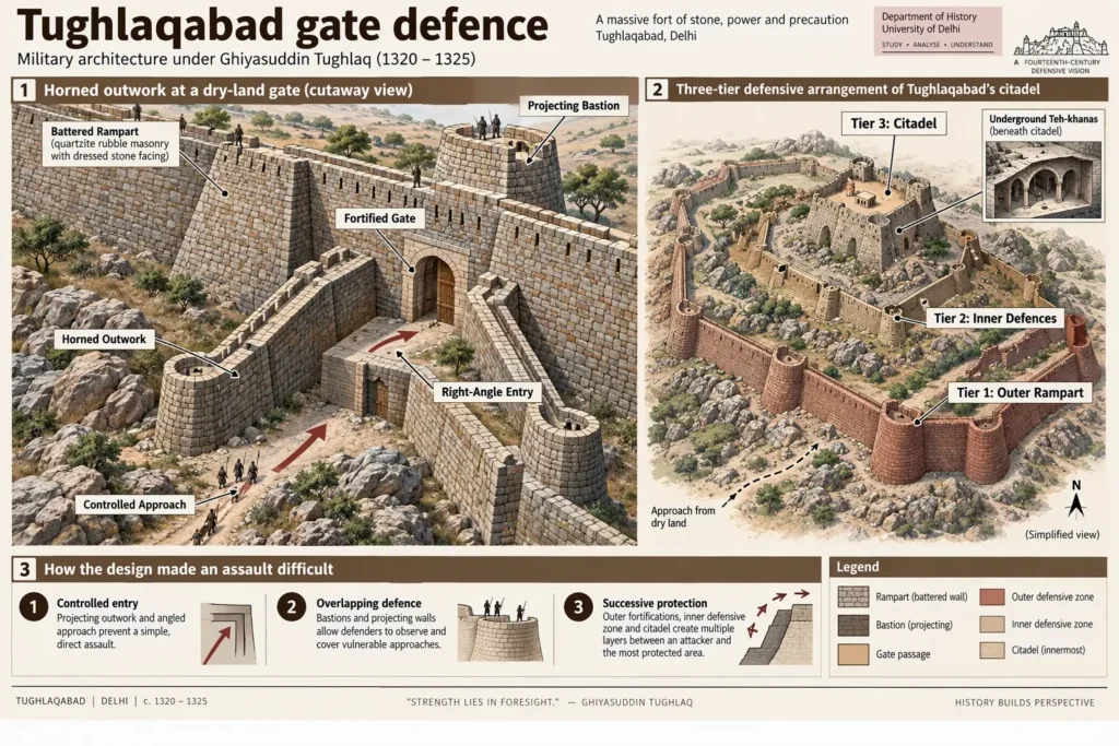
The citadel is the smallest part and the most heavily defended. According to Sahapedia, it has four large corner bastions, a tank almost 15 m deep, underground chambers (teh-khanas), escape passages and, at the highest point, Bijay Mandal (also called Badi Manzil). Both Sahapedia and Rezavi describe a three-tiered defence system here, and Sahapedia says it is the only part of the fort with all three tiers. In Rezavi’s description the tiers are: a battered lower wall with a ledge, a vaulted gallery and arrow slits above that, and battlements on top.
| Zone | Main functions | Key features |
|---|---|---|
| City | Housing, markets, grain storage | Irregular trapezium outline, grid-like streets, Khas Bazar, silos, Jami Masjid |
| Palace area | Court and administration | Audience hall, royal square, baoli, four gates |
| Citadel | Last line of defence, Sultan’s private quarters | Bijay Mandal, tank, teh-khanas, escape passages, three-tiered defences |
Defensive design in plain terms
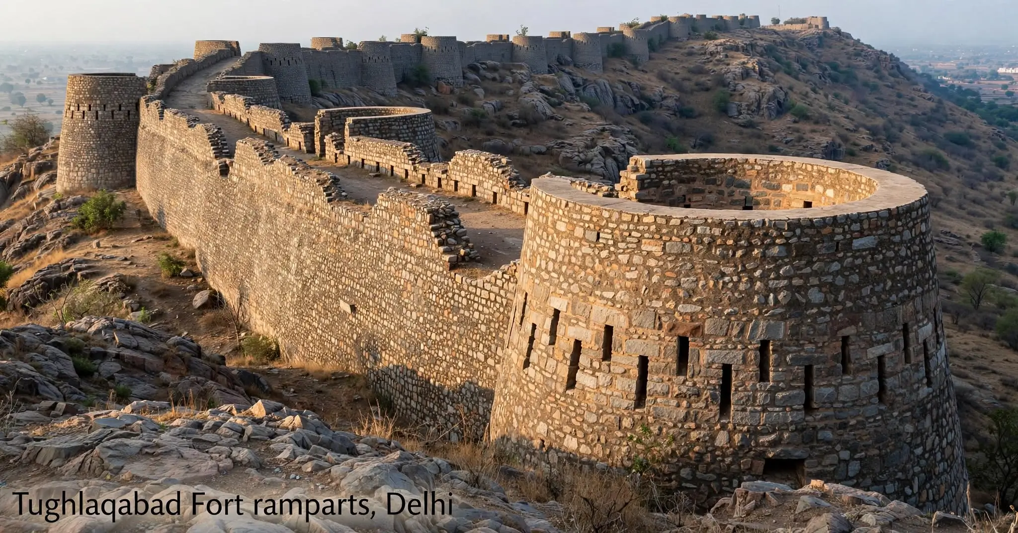
- Cyclopean, battered walls. The walls slope inward, thicker at the base than the top, with a sloped outer face (a batter). Sahapedia explains the exterior base is built against the sloping hill to save material.
- Semi-circular bastions projecting at intervals let defenders shoot along the wall face.
- Horned outworks. At gates facing dry land, two projecting barbicans joined by a wall form a shape Sahapedia compares to a cow’s head. Gates facing the lake did not need them.
- No straight entry. Gates are placed between bastions and turn at right angles.
- Pre-gunpowder fort. Sahapedia stresses that this is a fort for arrows and stone-throwing engines, not artillery.
The Lake, the Dam and Water Supply
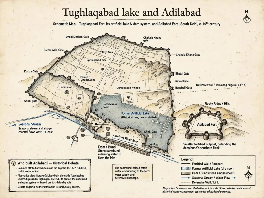
Water is the key to the abandonment debate, so know the system well. The southern lake was created by damming the stream. Sahapedia notes underground sluices allowed excess water to pass, and the dam itself had to be defended on both flanks. That is why Adilabad exists: it defends the southern end of the bund, while the main fort defends the northern end. Rezavi mentions further hydraulic works, including two big step-wells (one in the palace area and one in the citadel) and the sluice gates, which Tatsuro Yamamoto and his team surveyed. Rezavi also describes the link between Tughlaqabad and Adilabad as a causeway that doubled as a dam holding the lake water. Separately, the causeway to the tomb enclosure rests on 27 arches through which the lake’s water flowed (Sahapedia), and today it is silted up almost to arch level.
Ghiyasuddin’s Tomb and the Pentagonal Enclosure
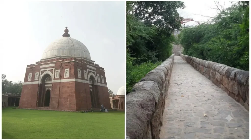
South of the main fort, linked by a causeway, stands a separate pentagonal fortified enclosure containing the tomb of Ghiyasuddin Tughlaq.
- Enclosure. Sahapedia says it was built to deny an enemy any foothold on a rocky outcrop near the palace and citadel walls. It has five bastions, silos, a protected well and platforms for access during a siege.
- Gateway. A red sandstone gateway with a touch of marble. Sahapedia calls this unusual for a fortification and explains it by the tombs inside.
- Tomb. A red sandstone square chamber with sloping (battered) walls and a marble dome with a high sandstone finial. Panels of marble and black stone relieve the red surface. Entrances are on the east, north and south, and the west wall has a mihrab. Because the tomb is aligned to the cardinal directions while the enclosure follows the outcrop, the tomb’s walls are not parallel to the enclosure walls.
- Zafar Khan’s tomb. Also in the enclosure. Narayan writes that it seems to be the earliest marble-domed tomb in Delhi, so use cautious wording.
- Who lies where? Sahapedia says the central grave is Ghiyasuddin’s; the next may be his son Mahmud Khan; the third may be a woman, possibly the Sultan’s wife. Wikipedia instead says the other two are believed to be his wife and his son and successor Muhammad bin Tughlaq. The sources conflict, so say “other burials are uncertain.”
- Road damage. Wikipedia notes that the Mehrauli–Badarpur Road cuts through part of the causeway.
Adilabad: Who Built It?
Adilabad is the smaller fort south-east of Tughlaqabad. Many popular sources say Muhammad bin Tughlaq built it, partly because he was known as “Adil” (the just). Rezavi’s summary also says Muhammad ordered it after Ghiyasuddin’s death. Narayan disagrees in part: because Adilabad is needed to defend the dam, he argues it must have been built together with the main fort under Ghiyasuddin. He allows that a large audience hall inside, built by Muhammad, could be how the fort acquired its later name.
For your answer: present it as a debate: popular and some scholarly summaries credit Muhammad bin Tughlaq; Narayan argues the fort’s function as dam defence points to Ghiyasuddin.
Legends: Nizamuddin Auliya and the “Curse”
Two traditions are attached to Tughlaqabad. Know both and know how to treat them.
- The baoli and the oil. The story goes that Sultan Ghiyasuddin had pressed workers into building his fort, while the Sufi saint Nizamuddin Auliya was building a step-well at his khanqah. Workers are said to have worked on the baoli at night; lamps were needed, the Sultan stopped oil, and the baoli’s water turned into oil. In some versions the saint then cursed the fort. The curse is remembered in the phrase “Ya base Gujjar, ya rahe ujaad”: either Gujjars would live there or it would stay deserted. Narayan notes the story is unlikely, even without its miraculous element, but he sees it as consistent with the idea that labour was heavily requisitioned. He adds that the village inside the fort today has a strong Gujjar element.
- “Hunuz Dilli dur ast.” When the Sultan, campaigning in Bengal, was said to be planning action against the saint, Nizamuddin is said to have replied that Delhi was still far away. In Hindi: “दिल्ली अभी दूर है।” The tradition ties this to the Sultan’s death on his return.
How to use this in an exam: mention the legends, say that they are later oral traditions and not evidence of why the fort was abandoned, and then move to the evidence. That one sentence is what lifts an answer above a narration of folklore.
The Death of Ghiyasuddin (1325): Accident or Conspiracy?
Ghiyasuddin died in 1325 (1 February, per Wikipedia) when a wooden pavilion collapsed at Afghanpur, about six miles from Tughlaqabad, while he was returning from a Bengal campaign. Because Muhammad bin Tughlaq had arranged the reception and succeeded him, the event has been argued over for centuries.
| Position | Who holds it | Note |
|---|---|---|
| Conspiracy by Muhammad | Ibn Battuta (14th century); some later chroniclers such as Nizamuddin Ahmad and Badauni are reported to share the suspicion | Some writers argue he had no reason to denigrate a ruler who had received him well |
| Natural accident (lightning) | Barani, as reported in secondary summaries | Some writers argue Barani, writing under Firuz Shah, may have softened the story |
| Divine will | Sarhindi, Tarikh-i-Mubarak Shahi, as reported in secondary summaries | A moral explanation rather than an investigation |
| Modern view of accident | Agha Mahdi Husain, as reported in secondary summaries | Note that the “plot” story is traced by him to Isami and Ibn Battuta |
Source caution: the attributions in this table come from summaries on teaching blogs, not from the primary texts. Before quoting a historian by name in an exam, check the original in your readings.
Why does it matter for Tughlaqabad? Because the death ended the founder’s personal commitment to the city, and Muhammad then built his own centres. It also gave the legend of the curse its dramatic payoff.
Why Was Tughlaqabad Abandoned? A Debate, Not a Single Cause
This is the highest-value part of the unit. Do not write a flat list of “six reasons.” Present the explanations, say who argues what, and weigh them.
| Explanation | Who or what supports it | How strong is the evidence? |
|---|---|---|
| Shift of capital by Muhammad bin Tughlaq | He built Adilabad and Jahanpanah, then moved the capital to Daulatabad (commonly dated 1327). Rezavi says Tughlaqabad “ceased to be the capital” | Well supported for the sequence. Dates for the final vacating differ (1327, 1329, by 1334 per Sahapedia) |
| Water scarcity and drought | Rezavi’s summary mentions a severe drought in North India together with the capital transfer as a probable cause of collapse. Many popular accounts name water as the main reason | Contested. The site had a purpose-built lake and step-wells, so the real question is whether the system failed or whether politics decided the matter |
| Firuz Shah’s new city | Firuz Shah (r. 1351–88) moved to Firuzabad, far to the north; Rezavi says this led to total desertion | Explains the final abandonment rather than the first |
| The Sufi saint’s curse | Oral tradition | A legend; useful for understanding memory, not causes |
| The historians’ caution | Sunil Kumar (University of Delhi), whose essays appear on your reading list, argues in his paper on Sultanate capitals that common explanations such as water supply, strategy or politics need more careful historical examination | Based on the abstract of his paper; read the full text before quoting |
What older student notes claimed, and what the evidence supports
The earlier version of this page listed six reasons. Here is how each stands:
| Older claim | Verdict |
|---|---|
| Water scarcity was the main reason | Possible but disputed. Present it as one view, not the answer |
| Inaccessibility hurt trade | Not supported. The surveyed city has a 20 m wide market street, grain markets and a planned road network |
| Administrative difficulty in ruling a large empire from here | Reframe it as Muhammad bin Tughlaq’s own rationale for a more central capital, not a settled cause of abandonment |
| Political instability | Too vague. Say instead that the founder’s death in 1325 removed the city’s patron |
| Epidemics and natural disasters | No source found. Removed |
| Shift of capital | Supported, but it needs a date and an agent: Muhammad bin Tughlaq, c. 1327 |
Key Takeaways: Abandonment
- Tughlaqabad was a capital for a very short time: occupied by about 1323–24, vacated by 1327–34.
- The best-supported cause is that Muhammad bin Tughlaq built and favoured other centres (Jahanpanah, then Daulatabad), and Firuz Shah later moved north.
- Water scarcity is widely repeated but disputed. The curse is a later tradition. Write the answer as an argument with attribution.
Comparison: Tughlaqabad and Other Sultanate Capitals
| Siri | Tughlaqabad | Jahanpanah | Firuzabad | |
|---|---|---|---|---|
| Builder | Alauddin Khalji | Ghiyasuddin Tughlaq | Muhammad bin Tughlaq | Firuz Shah Tughlaq |
| Approx. date | c. 1303 | from 1321 | Late 1320s (sources vary) | c. 1354 |
| Relationship to earlier cities | New walled settlement near the older city | New fortress city on a ridge, away from earlier settlements | Enclosure linking Lal Kot/Qila Rai Pithora and Siri (13 gates, per Wikipedia) | New city far north of Tughlaqabad (Rezavi) |
| Character | See Siri notes | Planned fort-city with palace and citadel | Fortified link between existing cities | See Firuzabad notes |
| Fate | See Siri notes | Vacated by 1327–34 | Not treated in depth in this article | Its founding led to the total desertion of Tughlaqabad (Rezavi) |
Use this table to answer “compare” questions. The unit’s main theme, the shift of capitals, is visible across the row of dates.
Tughlaqabad in the Historians’ Debate
Your syllabus readings frame Tughlaqabad within a larger question: why did Sultans keep moving?
- Athar Ali, “Capital of the Sultans: Delhi through the 13th and 14th Centuries,” is the standard overview on the reading list.
- Sunil Kumar has several readings on the list, including on courts, capitals and kingship. His point, as summarised, is that neat explanations (water, strategy) need testing against the evidence.
- Peter Jackson‘s essay, whose title frames Delhi as a vast military encampment, is also listed. It signals the theme of the Sultanate capital as a military base.
- Shokoohy and Shokoohy‘s architectural survey is the basis of Rezavi’s summary above. It is not on the DU list, but it is where the plan and the Iranian town-planning comparison come from.
Rezavi, summarising Shokoohy, reads the plan as influenced by Khurasanian (Iranian) models such as Bust, Nishapur and Tus, with a lower town, an upper town and a citadel. He also compares Tughlaqabad to Fatehpur Sikri, a “fossilised” town with buildings from one short period. Both comparisons are useful for original, attributed points in a long answer.
Tughlaqabad Today
Tughlaqabad is a ruined, protected site. Narayan’s survey notes that it still gives a glimpse of a pre-gunpowder fort and city because it is modestly well preserved. Wikipedia reports that a growing modern settlement, much of it described as illegal, occupies part of the former city area. Narayan says the village inside the fort has destroyed some features. For DU, the relevant lesson is analytical: a city planned around a dam and a lake shows how closely Sultanate urban planning tied water to defence.
How to Write a Tughlaqabad Answer (Exam Plan)
For a 15–20 mark question on Tughlaqabad:
- Open with a definition: who, when, where, and why it matters for the “shift of capitals” theme.
- Founding context: the Mongol frontier, the 1320 political change, the site’s lake.
- Layout: city, palace area, citadel, with two or three named features each.
- Water and defence: the dam, horned outworks, three-tier citadel.
- Tomb and Adilabad: one paragraph with the builder debate.
- Abandonment as an argument: capital shift, drought debate, Firuz’s move, and one line on the curse as legend.
- Close with a judgment that links back to the question.
Quick Revision: Timeline
| Year | Event |
|---|---|
| 1320 | Khusrau Khan’s coup ends Khalji rule; Ghazi Malik defeats him and becomes Ghiyasuddin Tughlaq (September, per Wikipedia) |
| 1321 | Construction of Tughlaqabad begins in earnest after the monsoon (Sahapedia) |
| c. 1322–24 | City declared capital / fort occupiable (Rezavi / Sahapedia) |
| 1325 | Ghiyasuddin dies when a pavilion collapses at Afghanpur; Muhammad bin Tughlaq succeeds |
| c. 1327 | Capital shifted to Daulatabad (common chronology); Tughlaqabad vacated after 1327 or 1329 |
| by 1334 | Fort definitely vacated (Sahapedia) |
| c. 1354 | Firuz Shah’s Firuzabad (Rezavi), leading to total desertion of the site |
Key Terms for Revision
| Term | Meaning |
|---|---|
| Bund | Dam built across the stream to make the lake |
| Batter | Inward slope of a fort wall |
| Curtain and bastion | Straight wall section and the semi-circular tower projecting from it |
| Horned outwork | Gate defence with two projecting barbicans, shaped like a cow’s head |
| Baoli (बावली) | Step-well |
| Teh-khana (तहखाना) | Underground chamber |
| Dar-us-saltanat | Seat of the Sultanate, i.e. capital |
| Bijay Mandal | Highest structure in the citadel, also called Badi Manzil |
| Khas Bazar | Main market street of the city |
| Causeway | Raised road across water, here 27 arches linking fort and tomb |
| Tughlaqabad (तुगलकाबाद) | The fort-city of Ghiyasuddin Tughlaq |
Conclusion
Tughlaqabad matters because it is a city built to last that did not last. It shows a Sultan using terrain, water and engineering to answer the Mongol threat, and it shows what happened when the next ruler had different plans. For DU, the strongest answers treat the founding as military and planned, the layout as three-part, and the abandonment as a debate about capital shifts, water and succession, with legend labelled as legend.
Continue Reading
Continue Reading (Delhi Through the Ages, Unit 2 and beyond)
- Siri: The Medieval City of Delhi – Case Study: the previous Sultanate city, useful for comparison.
- Ghiyaspur and Kilukhari Case Study: another Unit 2 option.
- Firuzabad: The Medieval City of Delhi Case Study: where the Tughlaq capital moved next.
- Delhi-i Kuhna’s Masjid-i Jami: The Quwwat-ul-Islam Mosque: the first Sultanate capital’s mosque.
- Humayun’s Garden Tomb and Shahjahanabad: the next unit in the course.
University of Delhi Previous Year Questions (PYQs)
DU Previous Year Questions
Verified questions from University of Delhi examination papers on Tughlaqabad and the changing cityscape of Sultanate Delhi. Tap a question to view a quick-answer guide. Probable questions are listed separately and are not verified PYQs.
1 Write a brief essay on any one of the following: (a) Ghiyaspur Kilokhri (b) Siri (c) Tughlaqabad (d) Jahanpanah (e) Ferozabad. +
2 Analyze the role played by any one of the following in the development of the Sultanate capital of Delhi: (a) Delhi-i-Kuhna’s Jami Masjid (b) Ghiyaspur-Kilokhri (c) Siri (d) Tughlaqabad (e) Jahanpanah (f) Ferozabad. +
3 Explain the significant shifts and transformations in the cityscape of Delhi in the 13th–14th centuries. +
4 Explain the significant shifts and transformations in the cityscape of Delhi in the 13th–14th centuries. +
5 What were the factors that shaped the developments in the cityscape of Delhi in the 13th–14th centuries? +
6 What were the factors that shaped the developments in the cityscape of Delhi in the 13th–14th century? +
7 Examine the development and changing cityscape of Delhi between the 10th and 14th centuries, with special reference to any two of the following: (a) Anangpur Fort (b) Delhi-i-Kuhna’s Masjid-i-Jami (c) Siri (d) Ghiyaspur-Kilukhari (e) Tughlaqabad (f) Firuzabad. +
8 Examine the development and changing cityscape of Delhi between the 10th and 14th centuries, with special reference to any one of the following: Anangpur Fort, Delhi-i-Kuhna’s Masjid-i-Jami, Siri, Ghiyaspur-Kilukhari, Tughlaqabad and Firuzabad. +
9 Write a brief essay on Siri or Ferozabad. +
10 Discuss Tughlaqabad as an imperial camp of the Tughlaqs and explain why it failed as a lived city. +
11 Compare the planning of Siri and Tughlaqabad as Sultanate capitals. +
12 Examine the legend of Nizamuddin Auliya’s curse in the abandonment of Tughlaqabad. Distinguish between history and popular memory. +
Frequently Asked Questions (FAQs)
Who built Tughlaqabad, and when?
Ghiyasuddin Tughlaq began it in 1321. Sources give slightly different dates for when it became usable (about 1322–24).
Is Tughlaqabad the third or fourth city of Delhi?
It depends on the count. If Lal Kot/Qila Rai Pithora is first and Siri second, Tughlaqabad is third. Some authors count extra earlier settlements and call it fourth.
Where is Tughlaqabad?
In South Delhi, beside the Mehrauli–Badarpur Road.
Why was Tughlaqabad abandoned?
No single cause is agreed. The best-supported factor is the shift of the capital by Muhammad bin Tughlaq and the later move by Firuz Shah to Firuzabad. Water scarcity is often cited but disputed
Did Nizamuddin Auliya really curse Tughlaqabad?
That is a popular tradition, reported in sources such as Sahapedia and Wikipedia. In exams, mention it as a legend and avoid presenting it as a cause
What does “Hunuz Dilli dur ast” mean?
It is Persian for “Delhi is still far away” (Hindi: “दिल्ली अभी दूर है”).
Was Ghiyasuddin Tughlaq murdered?
Ibn Battuta accuses Muhammad bin Tughlaq; other sources describe an accident. The question remains debated.
Who is buried in Ghiyasuddin’s tomb?
Ghiyasuddin lies in the central grave. Sources disagree on the other two graves, so say they are uncertain.
Who built Adilabad?
Popular accounts say Muhammad bin Tughlaq; Narayan argues it was built with the main fort because it defends the dam.
Should I choose Tughlaqabad as one of my two case studies?
The syllabus asks for any two from six. Tughlaqabad has strong surviving evidence and clear debates, so it suits students who like argument-based answers. Choose based on how much reading you can finish.
Which readings should I use for Unit 2?
The syllabus lists Athar Ali’s essay, Sunil Kumar’s essays and Peter Jackson’s essay, among others. Use these for the “shift of capitals” theme.
Subscribe to keep reading
You've used your free notes for now. Get Delhi Pathshala Premium for unlimited access.
Subscribe — ₹29/30 days